Wednesday, January 11, 2012
Wednesday, June 29, 2011
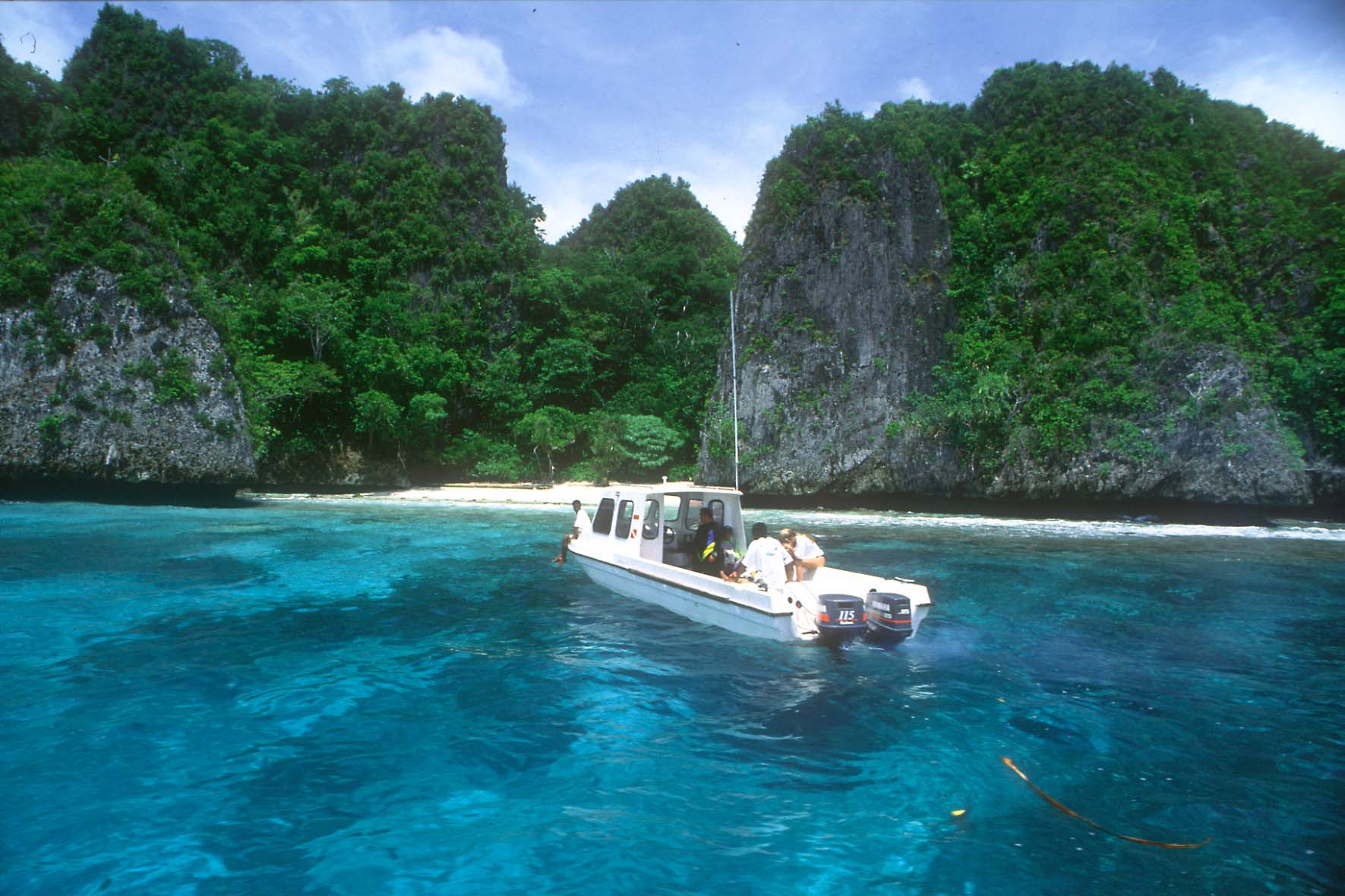
Raja Ampat Islands
Located off the northwest tip of Bird's Head Peninsula on the island of New Guinea, in Indonesia's West Papua province, Raja Ampat, or the Four Kings, is an archipelago comprising over 1,500 small islands, cays and shoals surrounding the four main islands of Misool, Salawati, Batanta and Waigeo, and the smaller island of Kofiau. Raja Ampat is new regency which separated from Sorong regency at 2004. It encompasses more than 40,000 km² of land and sea, which also contains Cenderawasih Bay, the largest marine national park in Indonesia. It is a part of the newly named West Papua (province) of Indonesia which was formerly Irian Jaya. The islands are the most northern pieces of land in the Australian continent.

According to Conservation International, marine surveys suggest that the marine life diversity in the Raja Ampat area is the highest recorded on Earth. Diversity is considerably greater than any other area sampled in the Coral Triangle composed of Indonesia, Philippines and Papua New Guinea. The Coral Triangle is the heart of the world's coral reef biodiversity, making Raja Ampat quite possibly the richest coral reef ecosystems in the world.
The area's massive coral colonies along with relatively high sea surface temperatures, also suggest that its reefs may be relatively resistant to threats like coral bleaching and coral disease, which now jeopardize the survival of other coral ecosystems around the world. The Raja Ampat islands are remote and relatively undisturbed by humans.

Marine tourism, as a sustainable alternative to overfishing, mining, and logging, has the potential to play a key role in the conservation of Raja Ampat’s spectacular underwater realm, while also creating real benefits for the local communities. This website was designed as part of a larger effort to support the growth of sustainable marine tourism in Raja Ampat and the conservation of these magical islands.
Please explore this site to find information on breathtaking diving opportunities, travel logistics, Raja Ampat’s new tourism entrance fee (which directly supports conservation and community development), and the tremendous conservation effort taking place in Raja Ampat.


The high marine diversity in Raja Ampat is strongly influenced by its position between the Indian and Pacific Oceans, as coral and fish larvae are more easily shared between the two oceans. Raja Ampat's coral diversity, resilience, and role as a source for larval dispersal make it a global priority for marine protection.
1,309 fish species, 537 coral species (a remarkable 96% of all scleractinia recorded from Indonesia are likely to occur in these islands), and 699 mollusk species, the variety of marine life is staggering. Some areas boast enormous schools of fish and regular sightings of sharks, such as wobbegongs.
The easiest way to get to Raja Ampat is to fly to Sorong via Jakarta or Singapore. Domestic travelers can also fly via Makassar or Manado.
Wednesday, August 20, 2008
GUNUNG RINJANI NATIONAL PARK
 There over 20 villages surround Mt. Rinjani and there are many routes up the mountain, but the main access is from Senaru in the north and Sembalun Lawang to the east. The challenging three-day Rinjani Trek route from Senaru to the crater rim (Plawangan), down to the stunning crater lake then on to Sembalun Lawang, is considered one of the best treks in South East Asia. Those heading for the summit usually prefer to start in Sembalun Lawang.A model for ecotourism in Indonesia, the community-based activities are focused on the Rinjani Trek Centre in Senaru, the most popular starting point for the tough trek. Developed with New Zealand Government assistance since 1999, the Rinjani Trek Centre embodies under one roof (satu atap) the unique partnership of the National Park, tourism industry and local communities that has been forged to manage and protect the Rinjani mountain environment.

The Centre is located at the trailhead above Senaru traditional village. It offers information and displays for visitors on the trek, the National Park, Sasak culture and a range of activities available in Senaru.Displays include maps, Park interpretation, village walks and environmental guidelines. All trek arrangements can be made here, cultural tours booked and purchases made of local produce and handicrafts.Park Fees: Fees are paid at the Rinjani Trek Centre. They contribute to the protection, maintenance and management of the National Park, Rinjani Trek route, village attractions and visitor facilities.Guides and Porters: Trained and licensed guides and porters are available. You will need three days and two nights to trek from Senaru via the spectacular crater lake, to Sembalun Lawang (or the other way). More time will be needed to explore the summit of Mt. Rinjani.All trek arrangements can be made and paid for at the Rinjani Trek Centre. If not with a guide, please ensure you are well equipped and have knowledge of mountain safety
Lombok Island

Lombok is an island in West Nusa Tenggara province, Indonesia. It is part of the chain of the Lesser Sunda Islands, with the Lombok Strait separating it from Bali to the west and the Alas Strait between it and Sumbawa to the east. It is roughly circular, with a "tail" to the southwest, about 70 km across and a total area of about 4,725 km² (1,825 sq mi). The administrative capital and largest city on the island is Mataram


The Lombok Strait marks the passage of the biogeographical division between the fauna of the Indomalayan ecozone and the distinctly different fauna of Australasia that is known as the Wallace Line, for Alfred Russel Wallace, who first remarked upon the distinction between these two major biomes.The island's topography is dominated by the centrally-located stratovolcano Mount Rinjani, which rises to 3,726 m (12,224 ft), making it the third-highest in Indonesia. The most recent eruption of Rinjani was in June-July, 1994. The volcano, and its sacred crater lake, Lake Segara Anak, are protected by a National Park established in 1997. The southern part of the island is a fertile plain where corn, rice, coffee, tobacco, and cotton are grown.The island's inhabitants are 85% Sasak (a people, closely related to the Balinese, but mostly practising Islam), 10-15% Balinese, with the small remainder being Chinese, Arab, Javanese, and Sumbawanese.
Tuesday, August 19, 2008
Way Kambas National Park


Way Kambas consists of swamp forest and lowland rain forest, but was extensively logged before becoming a reserve in 1972 so there is little primary forest. The reserve still has a few Sumatran Tigers and reasonable numbers of elephants. It is also provides excellent birdwatching, with the rare White-winged Duck among the species present. Accommodation is available at the village of Way Kanan, where there is a small guest house.
Another special feature of this national park is the Sumatran Rhino still present in the area. Only 275 remain in South East Asia today. In Way Kambas a managed breeding center or Sumatran Rhino Sanctuary (SRS) has been build up in 1995. At this moment 5 Sumatran Rhinos live at the Sanctuary, most have been translocated from zoos to the large enclosures (with natural habitat) at the SRS.

- the barking deer (Muntiacus muntjak),
- rusa deer (Cervus unicolor),
- mouse deer (Tragulus javanicus and Tragulus napu)
- Asian tapir (Tapirus indicus).
- The sun bear (Helarctos malayanus) is common.
- the flat-headed cat (Prionailurus planiceps),
- golden cat (Catopuma temmincki),
- leopard cat (Prionailurus bengalensis),
- fishing cat (Prionailurus viverrinus)
- marbled cat (Pardofelis marmorata)
- clouded leopard (Neofelis nebulosa)
- besides the Sumatran tiger itself.
-
Wayang Kulit (Shadow Puppet)

Wednesday, August 13, 2008
Panjat Pinang


Jimbaran


Saturday, August 9, 2008
Kelud Mount

Before November 2007
When Eruption Nov 2008
 When Eruption Nov 2008
Kelud erupted at about 3 p.m. local time on Saturday, November 3, 2007. The eruption was confirmed by the Indonesian government's Centre for Vulcanology and Geological Hazard Mitigation. Although no visual confirmation was possible when the eruption began because the volcano's peak was shrouded by clouds, Indonesian government volcanologists said seismic readings showed an eruption was under way. More than 350,000 people lived within 10 kilometres (6 miles) of the volcano. Surabaya, Indonesia's second-largest city and home to one of the country's busiest airports, is 90 kilometres (56 miles) to the northwest. Although local inhabitants were ordered to leave their homes in mid-October, many either did not evacuate or returned in the interim. Many villagers were reported fleeing the area in panic after reports of the eruption. But by early Saturday evening, Indonesian officials said the eruption that day had not been very large at all. Seismological equipment near the volcano's crater was still operating, and scientists said that indicated a small eruption at best.
However, early Sunday morning, November 4, Mount Kelud spewed ash 500 metres into the air, indicating a full eruption was taking place. "The eruption isn't over," Saut Simatupang, head of Indonesian Volcanology and Geological Hazard Mitigation Agency, said. Seismologists monitoring the crater said surface temperatures in Mount Kelud's crater lake rose on November 4 to 60.7 degrees Celsius (141 degrees Fahrenheit) from 43.9 degrees on November 3. At a depth of 15 meters (49 ft), the temperature jumped to 66.1 degrees Celsius on November 4 from 45.9 degrees Celsius on November 3. The extreme heat created a cloud of steam and smoke 488 metres (1,600 ft) high.
On November 5, new columns of smoke and steam erupted from the crater. Boiling water cascaded down the flanks of the mountain from the crater lake, and seismological equipment near the crater ceased working. Indonesian authorities said about 25,000 people remained in the danger zone, ignoring evacuation orders
The following day, a lava dome rose through the center of the crater lake atop the mountain. Closed-circuit television cameras showed the 100-metre (327 ft) long oblong island had pushed about 20 metres (roughly 69 feet) above the surface of the lake. The volcano continued to emit smoke, with plumes reaching a kilometre (3,280 feet, or six-tenths of a mile) into the atmosphere.
But after 48 hours of smoke and ash but no lava, Indonesian officials declared on November 8 that no eruption was immediate. Officials said the volcano was experiencing a "slow eruption" and was unlikely to explode as it had done many times in the past century
By November 12, Mount Kelud began spewing lava into its crater lake. The lava dome, which had expanded to 250 metres (roughly 275 yards) long and 120 metres (131 yards high), cracked open and lava began oozing into the surrounding water. Smoke rose more than two kilometres (1.2 miles) into the air, and ash dusted several villages around the volcano
On November 14, smoke billowed 2.5 kilometres (1.5 miles) into the air, and light ash covered villages 15 kilometres (9.3 miles) away
Wednesday, August 6, 2008
Toba Lake

This lake is about 1,700 m2 in size with the depth of approximately 450 meters. About 906 above sea level, this lake hosts various interesting plants. Some people, viewing the sunrise and sunset around this area, claim that Toba manages to help them forget their problems--even though only for a while.
Getting There
By renting a car from Medan to Parapat. Parapat is 185 kilometers away from Medan. It will take about 4 hours to reach this place. You can also ride a bus or join a tour to visit Toba Lake.

Where to Stay
Numerous inns and hotels are available in Parapat. Some hotels even have their own swimming pools and jacuzzi.
Monday, August 4, 2008
Cimaja Beach Pelabuhan Ratu
 The Pelabuhan Ratu area, a favorite weekend surfing destination for expatriates and a growing number of Indonesian surfers based in Jakarta, is the most crowded of West Java's surfing grounds due to sheer ease of accessibility. Most of the surf pounded beaches in the Pelabuhan Ratu resort area-also called Samudra Beach are just that: pure beach

The Cimaja break, a right that rises off a rocky reef, is reached by walking about 300 meters from the main road through beachfront sawah (rice paddies). This spot is consistently surf able because it has a solid and angular rock bottom perfectly attuned to south and southwest swells rising out of the Indian Ocean. Its rights peel off in front of a cobble-stone and boulder strewn beach that clatters like a series of giant castanets every time a wave set rolls in.
Bunaken Sea

Bunaken National Park in northern Indonesia is part of the North Sulawesi region. The National Park covers the northern tip of the larger island of Sulawesi, a number of smaller islands, and a vast expanse of water. North Sulawesi as a whole is a marvelous haven for diving. It has been estimated that there are over 150 prime diving sites in the region.
The area offers ideal conditions for diving. The water is warm and crystal clear - with visibility up to 40 meters. The underwater profiles range from coral reefs with dramatic drop offs to wide-open sand flats. In addition, there are some fast-flowing underwater currents. Even though Sulawesi is one of the more remote areas of Indonesia, it is easily accessible. Manado is served by an international airport with direct international flights from Singapore and the Philippines. From within Indonesia, Manado has good connections from all major cities. It is no wonder that over the years North Sulawesi has become one of the most popular diving destinations in Asia.
 A Group of islands consist Bunaken, Manado Tua, Siladen, Gangga, Mantehage and Nain where located in North Sulawesi is one of Main Diving Destination in the world in Indonesia. Underwater formation which form a great wall underwater offer great sensation for scuba diver in the world.

From Macro Object to Whales can be seen in Bunaken all year. Dive sites in Bunaken ussually give us over than 25 meter vizibility and hundreds divers from all over the world dives in these area. New dive sites founded every year by local diver in Manado.

A flat island about 15 km from Manado, with a friendly people. The coral reefs off Bunaken island shouldn't be missed while you are in Manado. These magnificent virgin reefs are still relatively unspoiled. The drop-off walls at Liang cove is not only rare in the world, with caves, gullies and caverns, harboring an immense wealth of marine life. Spectacular formation of reefs begin with flat at about 5 m depth. These plunge downward to form underwater vertical crevices with often reach depth on several hundred meters. On these beautiful reefs, a wonderful collection of marine life thrives.
The Bunaken reef is a chain of over 40 five star dive spots. The Marine Park is spectacular with the greatest concentration of tropical fish, coral species and world famous wall diving.Clear, warm waters (sea temperatures usually range between 27-30 degrees C), light currents and calm seas allow easy access to the underwater attraction awaiting visitors to the five-islands of the Bunaken-Manado Tua National Marine Park which sits directly offshore of Manado. Bunaken is the standout favorite, with the highest density of schooling fish and the greatest probability to see larger species such as turtles, sharks, and napoleon wrasse. There are enough sites here to keep any diver happy for over a week without going elsewhere.
Friday, August 1, 2008
Cakalele..a Warriors Dance
Saturday, July 26, 2008
National Park "Ujung Kulon"
 Ujung Kulon National Park is the first national park, founded in Indonesia. The park (80,000 ha) lies on a peninsula in south-west Java and includes the islands Pulau Peucang, Pulau Panaitan and the Krakatau archipelago.


Friday, July 18, 2008
Sewu Temple

Thursday, July 17, 2008
Dreamland Beach - Bali
 Dreamland beach is similar in nature to the other beaches in Bukit Peninsula, but it is popular not only with the surfers, also with the beach lovers. It easy access combined with the presence of warungs serving BBQ seasfood and cold cold beer make it attractive to anyone who just wants to get away from the hustle of Kuta life.
Dreamland is located in the Pecatu countryside around 20 minutes from the Ngurah Rai Airport. Park in the lot at the top of the hill and walk down.

To access the beach you have to pass a gate which leads to a private Villa Park and passed the failed Pectau Graha developments. An investor confiscated local land and intended to build several hotels, private properties and a golf course. Somehow the government stopped the development and today there are numerous unfinished structures on all sides of the road.
You can go to the dreamland beach, to your vacation with friend or your family. Enjoy and watch the surfers, have a beer and a chat and watch the sunset on the ocean is a great full romantic things that you can do in Dreamland Beach Bali.
The area has a beautiful beach and panorama, with the high wave reaching 4 meters makes this place become a favorite place for surfers and boogie boards.
 The wave is hollow, fasts, and powerful and the quality is standard with reef's (coral, sharp rocks with sand) bottom, can only be safely explore by the experienced surfer. During the normal day, it will be few people do the surf, but at the weekend this place is crowded.
Monday, July 14, 2008
Prambanan Temple
 This is the most famous and also the most magnificent of Central Java's temples or more precisely complex of temples. Situated about 15 kilometers from Yogyakarta, the top of the main shrine is visible from a great distance and rises high above the scattered ruins of the former temples. Prambanan is the masterpiece of Hindu culture of the tenth century. The slim building soaring up to 47 meters makes its beautiful architecture incomparable. Seventeen kilometers east of Yogyakarta, King Balitung Maha Sambu built the Prambanan temple in the middle of the ninth century. Its parapets are adorned with bas-reliefs depicting the famous Ramayana story. This magnificent Shivaite temple derives it name from the village where it is located.
Wednesday, July 2, 2008
Krakatau

Indonesia belongs to one of the most volcanic and seismically active region in the world. There are 128 active volcanoes of which 76 had eruption in historic time. These were occurred in 3 belts which one of is Lesser Sunda Islands where Krakatau is located. The Indonesian Volcano logical Service classified those volcanoes as "class A" volcanoes, of which there 12 in Sumatra Island. One of those is Krakatau. Krakatau is located in South Lampung region in Sunda strait, between Java and Sumatera.
In the early time Krakatau estimated was a volcano with 2000 M in height. The catastrophic eruption destroyed the volcano and remained 3 islands i.e. Rakata, sertung and Panjang. The renewed activity was started at Rakata, and an island of strato volcano was built up with diameter of approximately 5 Km and 800 M high. After its dormancy, next activity was shifted come into existence with the height approximately 456 and 120 M above sea level. In 1883, the 3 summits (Rakata, Danan & Perbuatan) was erupted and leaving a piece of small part of Rakata. The boom of explosion causing tremors and was heard as far as Singapore and Australia. The wave washed everything away around volcano. The volcanic ash was blown in to the atmosphere, as much as 4 cubic miles. In 1927 the new activity was occurred and then Anak Krakatau existed in to being. Now Anak Krakatau has reached 250 M above sea level. Anak Krakatau still active with its gush of steam and smoke, make it spectacular view.
Today we can come and step our foot on it searching closely the minerals (Volcanic bomb, lava, lapel) from the bottom of the earth which were thrown up through its crater. Krakatau and its terrific eruption, which is recorded in the history, now has invites every one to come and see for science as well as for pleasure. The way to get there is from Canti located in Kalianda about an hour driving from Bandar Lampung, and the boats will take to the Karakatau area. Near by the Krakatau there are Sebuku and Sabesi Island as for stopover and staying over night. It is only taken one and half-hour from Canti